Geometry and Symmetrykvijaykumar (2025-09-20 11:17:32)I woke early and left my hotel in Karol Bagh, heading to Dhaula Kuan. It was peak Kanwar Yatra time and sections of the road had been cordoned off for the pilgrims, Yet, they spilled on to the road often. I took a taxi to get me to the bus station, afraid I would miss the bus. He overcharged me, and it turns out the bus was empty and waited a long time after it was supposed to leave. Furthermore, the bus charged me an AC fare although the AC was not working. The bus conductor’s argument – God has created such a wonderful AC, why do you need the bus AC? My riposte – then I will pay God the difference in fare did not cut much ice.
But that was far from the biggest problem. The bus which had I had boarded with the intent of getting off at Bandikui went via Mandawar instead, and transferred me to a bus that dropped me off at Mehndipur bypass with the advice that there are lots of buses going to Bandikui from there. In fact, there were none. There were several going to Jaipur, some which stopped at Sikandra. Eventually, I settled for an e-Auto to take me the remaining 20-odd km to Abhaneri. Sharing the ride with me was a couple from Kanpur who had come to the Balaji Mandir and were going back to catch a train from Bandikui to Kanpur.
We go through fields of Barley trundling through some narrow village roads. We chat about farm productivity, fertility, and water tables. Ram Singh is full of information about such things.
I get off at Abhaneri. It is well past noon by this time. The complex has a small garden with shady trees planted in it. There are several families who have taken the opportunity to lay out a picnic spread. The elders settle down with a sigh while the kids run around and climb the trees, making for several photo opportunities.
The entrance to the complex feels cool, thanks to the pedestal fan that the staff has set up next to their table.
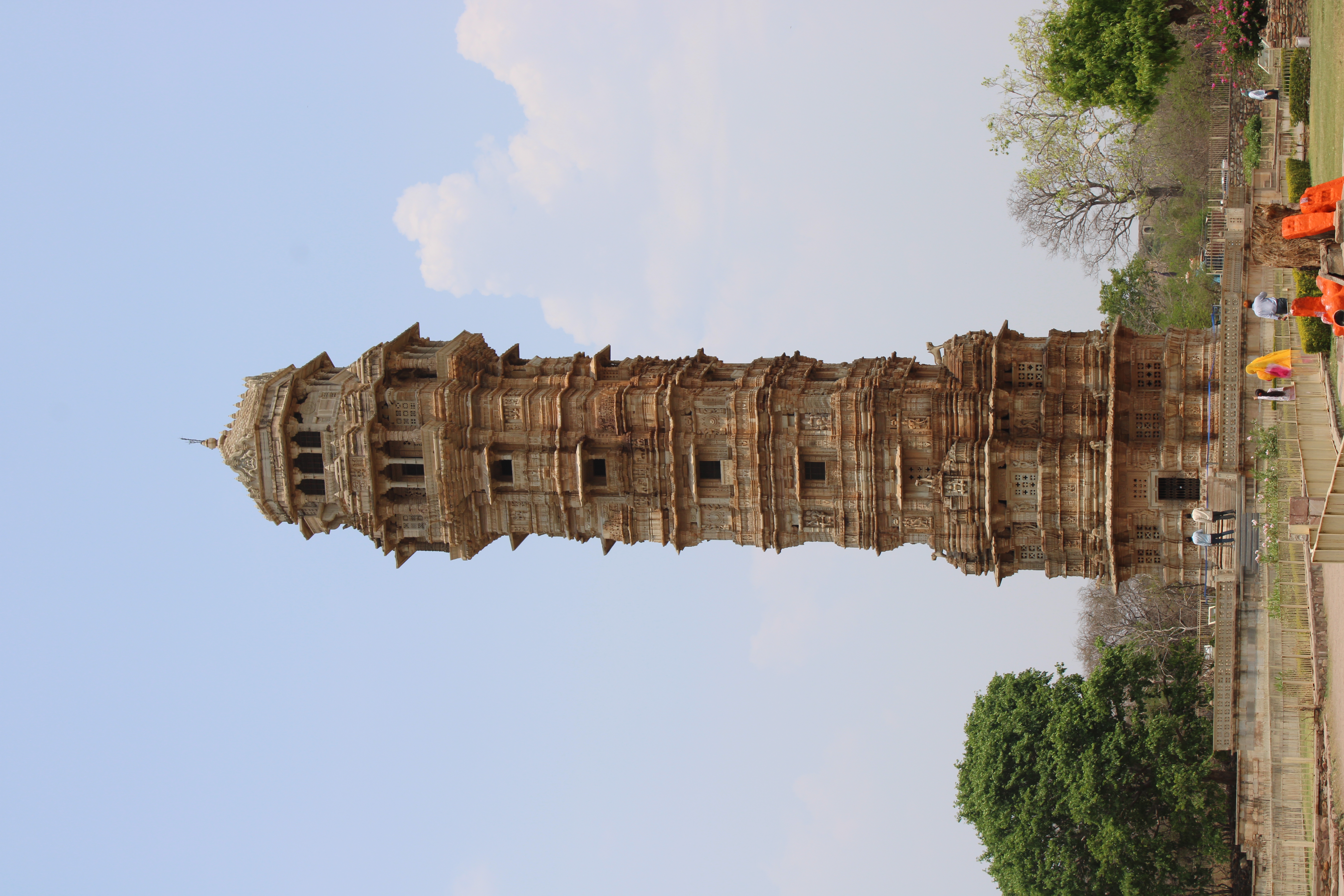
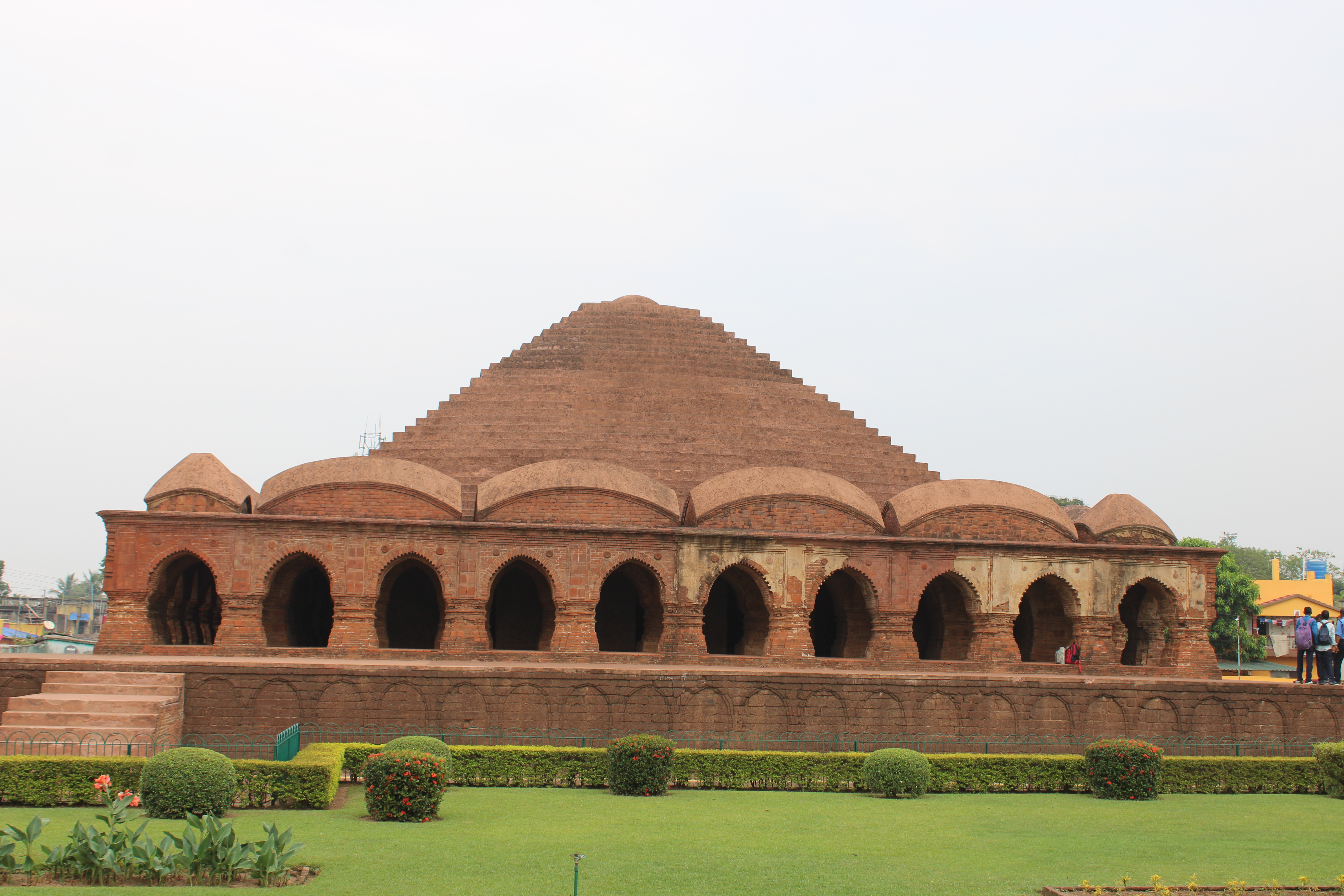
Chand Baori was built by King Chanda of the Nikumbha Dynasty in 9th century AD. It has 3,500 perfectly symmetrical, narrow steps which takes the form of a double flight of steps on three sides of the well, leading down to the surface of the water below. The entrance on the north via a six-storeyed pavilion with pillared galleries, projecting porches and decorated eaves and corbels.
At the lower-most level, there are two projected offsets to house a niche in each of them. These two niches serve as shrines, the right one houses the deity Ganesha while the left one has an image of Mahishasuramardini.
The upper-most level is a later day addition by Chauhan rulers.
A pillared gallery has been built on the other three sides (West, South, and East) and is under maintenance. A number of exquisitely carved idols lay strewn around in these galleries. These idols range from six to eighteen inches in height and most of them are of deities from Shaivite traditions – such as Shiva, Parvati, Ganesha and their attendants.
Across the street, on the west, is the Harsiddhi Mata temple or the Harshad Mata temple, of the same vintage as the step-well. It is in an advanced state of disrepair, despite multiple conservation efforts, leaving blocks of stones jumbled together obviously not in the right place. Despite this, it is a temple of great beauty and grandeur. The carvings on the plinth are of particular delight.
It is time to leave now, and I catch a ride to Bandikui train station. The carriage is packed (I have to board the general compartment, not having made prior bookings) and I spend the first hour or so standing before eventually managing a seat on the luggage rack. It is late evening by the time I get off at Delhi Cantt station and discover that the Delhi Cantt metro is a long way away from the railway station of the same name. An auto-ride and a cold mosambi squash later I am on the metro, back to my hotel for a warm bath and bed.
Note to self: Next time, plan ahead and take the train.
Public Spaces. Private Spaces.kvijaykumar (2025-09-20 11:17:32)It was late in the evening by the time I reached Gwalior. The station is under construction and I have trouble finding the retiring room that I had booked in advance. The rain and the dug-up streets do not help. Like many other retiring rooms I have used at railway stations, it is clean and roomy, just a little less conveniently located. Perhaps when the construction is done, this will be better integrated with the rest of the station complex.
I leave early the next morning, armed with Google Maps. I take a share auto to Phoolbagh from which I intend to take the ride to the fort. The fare quoted is outrageous for the short distance that Google Maps says it is, and I walk off in a huff, with Google Maps as my guide (turns out Google Maps was showing me the directions to something that was at the top of the hill, but not the way to get to the top).
I turn into a by-lane and then into another and come upon a Jain monastery cum temple. I know now that Google Maps has somehow misled me, but curious, and since I have made it this far anyway, I take off my shoes and trek up the broad and gently rising steps where I come upon a fascinating set of statues cut into the rock-face. This is the Gopachal ek-shila colossi, a set of large statues of Jain Tirthankaras, some seated, some standing, with beautiful relief work depicting various themes from Jain iconology.
It has been raining all night and off-and-on this morning as well. My feet are a mess and there is no water to wash my feet after I get back down from the Gopachal colossi. I shove my socks into my pockets and slip into my shoes. More on the shoes later.
I make my way back down to the main road, and suitably chastised, take an auto to the Fort Gate which is a little farther than Google Maps had me believe.
The auto leaves me at the foot of the hill on top of which the fort stands, at Badal Gate. To its right is the entrance of Gujari Mahal, which is not yet open to visitors at this early hour. There is a music school on the left from which I can hear a less-than-euphonious chorus of students practicing their scales and notes.
The fort sits atop the northern end of the 2.8km long rocky outcrop of the Vindhya mountains, with a width of about 900m, and a maximum height of 104m. The fort measures nearly 2.5km in length and varies between 200m and 725m in width.
The climb up from Badal Gate to the fort is not very long, but is steep enough to make for a brisk morning’s exercise. I go past the Ganesh gate (with the dove cote next to it), and the Laxman Gate before getting to the Hathi Pol at the top of the hill.
There is the small Chaturbhuj temple just before one gets to the Lakshman gate. There are signs pointing to “ZERO” along the path. That is a reference to the inscription in the temple which is one of the earliest known depictions of the number “0”.
As I pass through the Hathi Pol gate, I see the open space on the left and the ramparts of the fort overlooking the town below. There are a number of people here, some using the space and time to exercise. There is a group who are practicing wrestling moves. Some here just to spend time with friends (the trek up to the gate was probably their morning walk). I suspect I would see chess players too if I were to come here on a finer day. I am reminded of Anisha’s writings and speeches on public spaces in heritage structures and how restoring that status is critical for ensuring continuing health of these heritage structures.
I was advised by my cab driver in Khajuraho to explore the Man Mandir palace where sunlight pierces the building to ensure that even rooms two floors below the ground receive natural light.
Man Mandir palace is hard to miss. It is the most visible, and by far the most beautiful structure in the fort. It is also the only one that is open this early in the day. I take my ticket and go into it. I have to climb two sets of stairs to get to the entrance.
I am greeted by two finely decorated courtyards surrounded by lavishly decorated residential quarters. The stairs to the upper floor are locked out to visitors. But there are stairs which we can descend to the two lower floors, on each of which there are large circular rooms. The windows of these rooms open on to the cliff-face on one side, and on to the open space adjoining the Hathi Pol gate on the other.
So, that is the secret of the “sunlight under the ground”. The entrance on the second floor creates the illusion that these floors are below the ground.
It is not yet time for the rest of the fort to be opened to the public (there is a separate ticket for that), so I have to hang around a little while longer, watching the people gathered there for their morning routine.
Eventually, the ticket window opens and the gates to the other part of the fort open. My canvas shoes, otherwise comfortable for walking, are drenched by now, and in the absence of socks, chafing against my feet.
This, the northern section of the fort, has further palaces — in various states of decay and disrepair — the Jahangir Palace and Shah Jahan Palace, the Vikram Mahal, and the Karn Mahal. There is a reservoir with the macabre name Johar Kund, and to its north, the Cenotaph of Bhimsingh Rana.
The armory building on the west of Johar Kund is a British area structure, with a distinctively colonial design.
Thus, within a few hundred yards of each other, one finds evidence of the evolving architectural styles and motifs from the simple porch of the Chaturbhuj temple, to the Gurjara-Pratihara style of the Man Mandir palace, with the segue into Mughal style palaces, and eventually, the colonial style armory.
The rain has been relentless, and I duck into the ASI museum (which has a separate ticket) partly to escape the rain (despite being armed with an umbrella).
Once the rain relents, I move south, past the Man Mandir palace and the assi khamba ki baodi, a circular step-well with an elegant eighty pillared pavilion.
The ticket for the rest of Gwalior fort, covers the Saas-Bahu temple and the Teli mandir as well, which are half-a-mile further to the south. That short walk aggravates the callouses on my feet significantly, and walking is getting to be bit of a punishment by now.
The next stop is the Saas-Bahu Temple. This is the colloquial name assigned to the twin buildings on the south-eastern side of the fort. The original name of the temple was almost certainly Sahasra-baahu temple (the temple of the thousand-armed one), which has been corrupted to Saas-Bahu temple (meaning mother-in-law and daughter-in-law temple), which conveniently denotes the larger and smaller of the two structures. Unusually, the temple plan is on a north-south axis with its entrance on the north.
There are few visitors here at this time — attributable in part to the weather and a still-early time of the day. I run into Charu Govil, who is here from Gurgaon, exploring Gwalior and other tourist destinations in the vicinity. A school teacher by profession, she organizes heritage walks in Gurgaon. We chat, and oblige each other by taking photos.
I walk on to the Teli temple. It is the tallest structure in Gwalior fort, at about 25m. The spire ends in a wagon-vaulted shape, unusual for a shrine in northern India (this is more prevalent in temples and gopurams in southern India). This adds one more ingredient to the potpourri of architectural styles in the fort.
I pass the Scindia School on the way here — a large gated, manicured, and restricted property — sterile and forbidding in comparison to the friendly and open yards at the Hathi Pol, and I am reminded once more of Anisha’s thoughts on public spaces.
A small group of tourists shows up at Teli Mandir. The guard refuses to allow them entry until they have tickets — which are being sold at the main fort 800m away. The absurdity of the arrangement does not appear to have crossed the minds of the officials who designed it. I persuade the guard to allow the visitors to roam around — it is raining heavily again now, they have no other place to shelter, and it is impractical for them to go to the fort, get tickets, and come back here. The guard relents.
I continue, with my feet hurting with every step I take.
Fortunately for me, I come across a group of Sikhs who have come to the Data Bandi Chhod Sahib Gurdwara, who agree to take me down the hill in their jeep.
We speed down the cliff and I see the Jain statues once more — this time on my left. I suspect it is not the same statues that I saw in the morning, and I discover regretfully that that was indeed the case. These are the Siddhanchal group, the largest of five groups of statues surrounding the hill on which the fort is built.
Dropped off at the Koteshwar Mandir road, I hire an auto to take me to Ghous Baba’s tomb, and Tansen’s tomb. There are vendors selling teasel gourd (Kantola) on their carts and by the roadside. This is a vegetable that is somewhat rare and pricey in Hyderabad and I consider taking back some on my train back in the night, but I eventually give it a pass.
The Koteshwar mandir is another example of a temple with a domed spire, matching the Pratapeshwar that I had seen in Khajuraho just the day before.
My next stop is the Jay Vilas palace, a nineteenth century palace built in European style by Jayajirao Scindia and designed by Lt. Col. Sir Michael Filose. The major part of the palace is now the “Jiwajirao Scindia Museum” which opened to the public in 1964. The public access to the palace is through twisting by-lanes with the last stretch limited to pedestrian access or paid golf carts only.
There is a small café at the gate of the palace where I have my first meal of the day, after a vexingly long wait. The palace features a resplendent array of artefacts, lavishly fitted rooms, and the dining room with the famous food train. It leaves me rather cold.
I make my way back out and see that the palace gates which open on to the broad Moti Mahal Road being opened to let in an official vehicle. I ask to be allowed to leave from that gate, while it is still open, but I am brusquely shooed off and forced to make my way back through the same back-lanes I had come through.
My feet are killing me and I am all set to go back to my room at the station, but I let myself be talked into a visit to the Sun Temple, by my auto-driver.
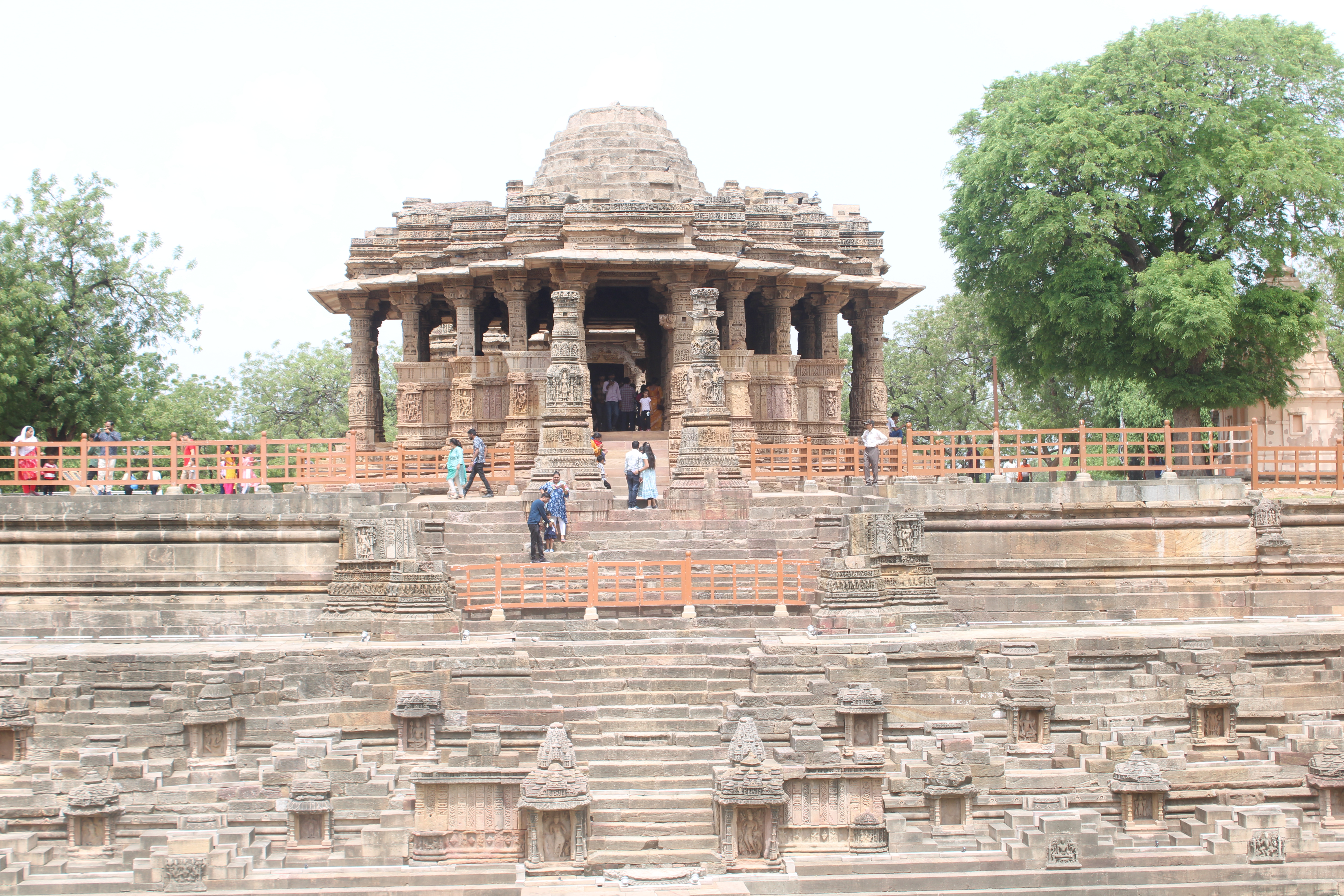
The temple is an attempt to make a replica of the Sun Temple of Konark. The scale is much smaller, of course, and the external walls a gross oversimplification of the ornate original. The Birlas have built beautiful temples in Delhi and Hyderabad. I am saddened that they chose this ersatz representation in Gwalior.
But now, it is time to put my blistered feet up, and catch the train back to Hyderabad.
Big Templekvijaykumar (2024-06-14 06:17:35)I reached Thanjavur early in the morning and was off on my way to the Brihadeeswara temple after a quick shower.
Curiously, the signs on the streets do not point me towards the Brihadeeswara temple, but they all say 'Big Temple', which is a translation of the colloquial name used locally - 'periya koil'. It is a short walk to the temple from the railway station, along broad, clean, and shady roads. There is a short bridge crossing the GA Canal which brings one to the main gopuram of the temple.
The Grand Anicut Canal (GA Canal) owes its origins to Karikala Cholan (2nd Century AD) who constructed the water reservoir of the Grand Anicut by raising flood banks in the River Cauvery to irrigate the wasteland beside the river. It has been maintained and enhanced by kings and governments since. The temple stands on the north bank of the canal.
The temple stands in a fortified compound, complete with a moat (fed by the Grand Anicut canal) and bastions. There are three successive gates to the temple, beyond the moat. The first of the gates is known as the Maratha gateway. It is an arched gateway with plain walls, but topped with beautiful stucco figures of Shiva, Parvati, Ganesh, Kartikeya, etc. There are two shrines on the left and right of the entrance door, dedicated to Ganesha and Subramanya. The second gate a towering gopuram, the Rajarajan Thiruvasal. It is richly decorated with sculptures. The third gateway, the Keralantaka, is a smaller gopuram, also richly decorated with sculptures. This third gateway forms part of the inner compound wall which forms the large courtyard (240 m x 120m) within which the temple stands. This compound wall features a number of nandi (bull) sentinels in various poses mounted on top of the wall.
The complex has, in addition to the main shrine, five sub-shrines, for Chandikesvara, Amman, Subramanya, Ganesha, and the royal priest, Karuvar. There are two open pavilions, one each for Nandi, and Nataraja.
The temple is an imposing and awe-inspiring sight to behold. The crowds are thin this morning, but the darshanam is still a hurried affair. I am bustled out of the temple clutching my share of coconut, plantain (still very raw), flowers, and vibhudi packet. I sit down on the parapet of the stairs on the south side. I am a long way from home, and still a long time before I can get home. I eat the plantain but there is not much I can do with the half-coconut. I give it to a young couple who are seated next to me.
It turns out the couple are from Sri Lanka, and are here on a religious trip, with plans to go to the Nataraja temple in Chidambaram next. We talk about tourism and temples in India, the beauty and allure of Sri Lanka from a tourism perspective, and how governments everywhere are falling short in their efforts to protect our heritage.
There are a number of sub-shrines in the complex, and ASI has done a good job of marking and annotating the structures in the complex.
An unusually shaped, red-coloured building with bulbous domes attracts my attention while on the way to the temple. I go back to the building after my visit to the temple. It is the old district collector's office, now converted into a museum. It is well kept and the exhibits are well annotated. There are several musical instruments on display here, including the famous Thanjavur Veena. There is also a model of the Kaveri basin, built to scale, showing the several dams along its path, and the location of the temple. The annotations for this model are in Tamil, and a young lady on a trip with her parents very helpfully translates and explains each of them for my benefit.
My visit to the temple has whetted my appetite, and I resolve to visit the temple's twin in Gangaikonda Cholapuram the next day.
I leave early the next morning for Gangaikonda. I have to switch buses at Ariyalur to make it to Gangaikonda. Thankfully, the wait time is minimal. The Brihadeeswara temple at Gangaikonda stands on the NH81 and I rush to the gate in excitement as the bus rumbles past it. This temple is the junior of the Big Temple in Thanjavur in every respect - age, scale, richness of sculptural ornamentation, reputation, and even the crowds that visit it - but is very impressive on its own, nevertheless.
A group of college students is visiting the temple on the day I was there, and posing for photographs. There is also a young woman who is having her photograph taken in various dance poses, with the temple in the background, obviously getting her portfolio made. She stops self-consciously as I approach closer, and I back off immediately.
The glory days of Gangaikonda have long gone, and there is little else in the town now other than the temple. There is a clean but modest establishment outside the temple where I have a quick brunch. I am advised to take the return trip via Kumakonam and do so. Kumbakonam is a bustling town, larger than both Ariyalur and Gangaikonda, but my wait for the return bus to Thanjavur is longer. I browse through the colourful bazaars and have a rich ice-cream sundae before I board the bus back to Thanjavur.